Victoria > West Coast
Portland
| Type | Dunes & cliffs |
| Conditions | Various - all except N |
| Height | Various - 30' - 400' / 9m - 120m asl |
| Rating | Various - PG2 / HG Supervised to PG5 / HG Advanced |


- Murrells Beach NW Navigate Map
- Murrells Beach Navigate Map
- Nuns Beach Navigate Map
- Cape Bridgewater Seal Cliffs Navigate Map
- Amos Road - Whites Beach Navigate Map
- Bridgewater Bay Navigate Map
- Dutton Way Navigate Map
- Discovery Bay Navigate Map
- Golf Course / Harbour Trust Road Navigate Map
- Bishops Rock / Shelly Beach Navigate Map
000 Emergency Markers (?)
- GSW418: Murrells Beach
- GSW408: Cape Bridgewater Seal Cliffs
- GSW402: Amos Road - Whites Beach
- GSW401: Discovery Bay
- GSW526: Golf Course / Harbour Trust Road
- GSW413: Bishops Rock / Shelly Beach
Landowners
Parks Vic and others. Traditional owners: Gunditjmara People
Contact/Responsible
DynasoarersDescription
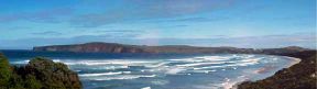
A range of coastal dunes and cliffs which suit a variety of wind conditions and skill levels.
Takeoff
Portland has got it covered, particularly as conversation with local sea salt suggests W and SE winds prevail during the summer months.
Murrells Beach NW
(W-NW)PG4, PG2 sup by PG4 / HG Sup supervised by Int. This is an alternate launch for Murrells which can be flown if the wind is more from the right.
Murrells Beach
(SW-WNW)PG4, PG2 sup by PG4 / HG Sup supervised by Int. Superb site with rounded takeoffs and easy beach or on top landings. The WNW face is about 250' high whilst the SW face is around 180'. Suitable for all ratings under the right conditions.
Nuns Beach
(ESE-ENE)PG4, PG2 sup by PG4 / HG Sup supervised by Int. Launch from the cliffs in front of the hospital and fly both sides of the lighthouse.
WARNING: Large medical helicopter may land on helipad at hospital. You must land well away from the area immediately, do not cross approach path. No further flying until helicopter has departed.
Cape Bridgewater Seal Cliffs
(ENE)PG4 / HG Intermediate. A sheer 120m/400' cliff. Good top landing. Absolutely no bottom landing directly below or to the right, but only 1km to safe beach landing at Cape Bridgewater Surf Life Saving Club. Emergency landing near seal pier to left. Launch is about 3/4 of the way up just before the fence starts.
Amos Road - Whites Beach
(WNW-NNW?)PG5 / HG Adv. This site hasn't been flown much, use caution and your own judgement. PG can beach launch if it's strong enough. Watch for rotor on launch if off to the left. Other launch spots may be more suited depending on conditions. Whites beach is the only bottom landing in either direction for a long way. Overshooting the landing is not an option.
Bridgewater Bay
(SSE-SE)Car park launch PG4, PG2 sup by PG4 / HG Int. Beach launch PG2. Steep faced dunes rises from 30' at the Bridgewater Cafe to 60' 3km east with a good beach landing. Launch from the car park infront of the Lodge. Please do not walk up the dunes because of revegetation or this site could be lost. All the dunes are part of the National Park.
Dutton Way
(SE)PG+HG. This is private land but the farmer has no problems with pilots flying. A grassy hill that is quite shallow, needs a stong wind to be soarable. The farmers house is opposite the caravan park on Dutton Way.
Please get permission before flying this site.
Discovery Bay
(SW)Discovery Bay provides many kilometres of low dunes and a good beach if you do not mind a walk.
Golf Course / Harbour Trust Road
(NE)PG+HG. Just before the Golf Course two minutes from the centre of Portland there is a 2km stretch of 80+' grassy cliff with a small beach below takeoff suitable for INTERMEDIATE.
Bishops Rock / Shelly Beach
(S)PG+HG. The launch is located on Bishops Rock. A stretch of 80' to 100' cliffs facing south with a good launch area. Top landing is possible (but difficult if overshot) and bottom landing can be a difficult depending on the wind conditions and tide. An INTERMEDIATE - ADVANCED site, very tricky if the wind is light or off. Do not launch from the revegetation areas on the beach. 
The launch at Bishops Rock lies atop and is enveloped by a Nyamat Mirring cultural heritage designated area of significant importance. We access the site under a cultural heritage permit issued by the Gunditjmara people to Parks Victoria. The approved launch and recovery area and access path are gravelled and we are required to confine our activities to the gravelled area. In particular we are directed not to walk upon or cause further deterioration to the rocky area to the immediate west of the gravelled area.
Significant effort has been expended by the Dynasoarers club and the VHPA to retain access to this key launch site. If we are to retain access for the long term pilots must fly within these restrictions. If you observe a pilot breaching the restrictions please report this to the Dynasoarers club.
Site preservation works were conducted in July and August 2025. Brush and regrowth have been established in the formerly clear area to the east of the car park. The launch is a gravelled area to the west of the carpark and is accessed by a short (15 metre) section of gravelled track. Setup launch and recovery may be conducted on the gravelled sections of the launch or the track and/or in the carpark. Please note that the gravelled track is part of the Great South Walk so there may be public walkers.
The gravelled launch is smoother and flatter than it was before, and there are fewer snag points as the rocky crags have been covered over. The launch area is adequate for two to four pilots, but smaller than it was before. On busy occasions, such as annual fly-in weekends, pilots & clubs are asked to manage the site carefully so that activities are restricted to the gravelled areas, as we must adhere to the cultural heritage permit.
