New South Wales > Hunter Valley
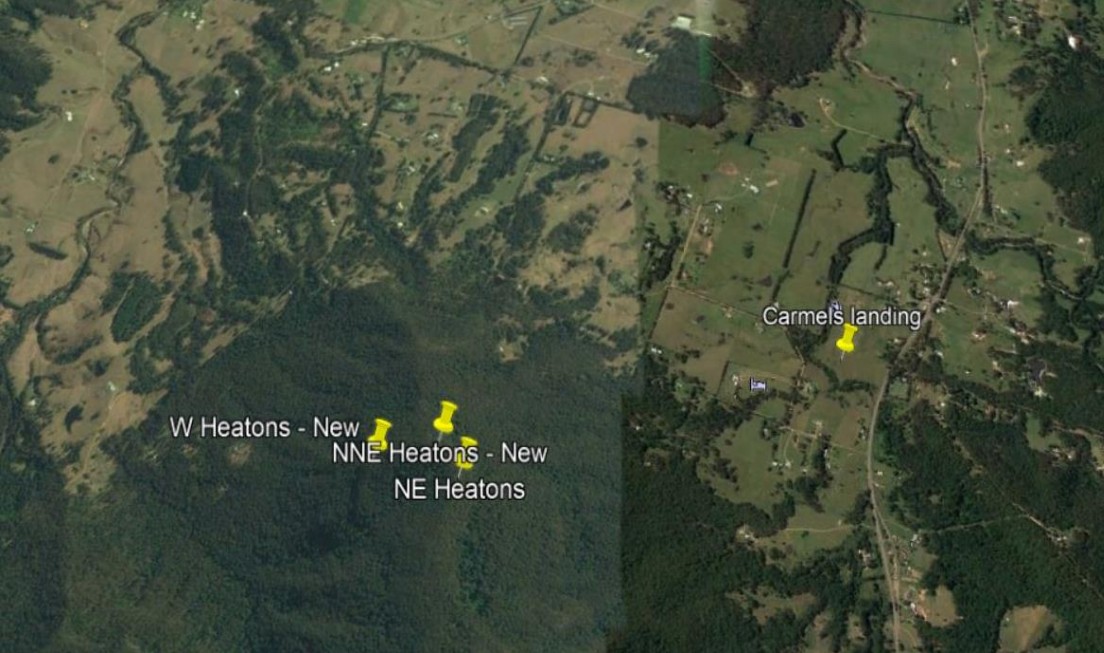
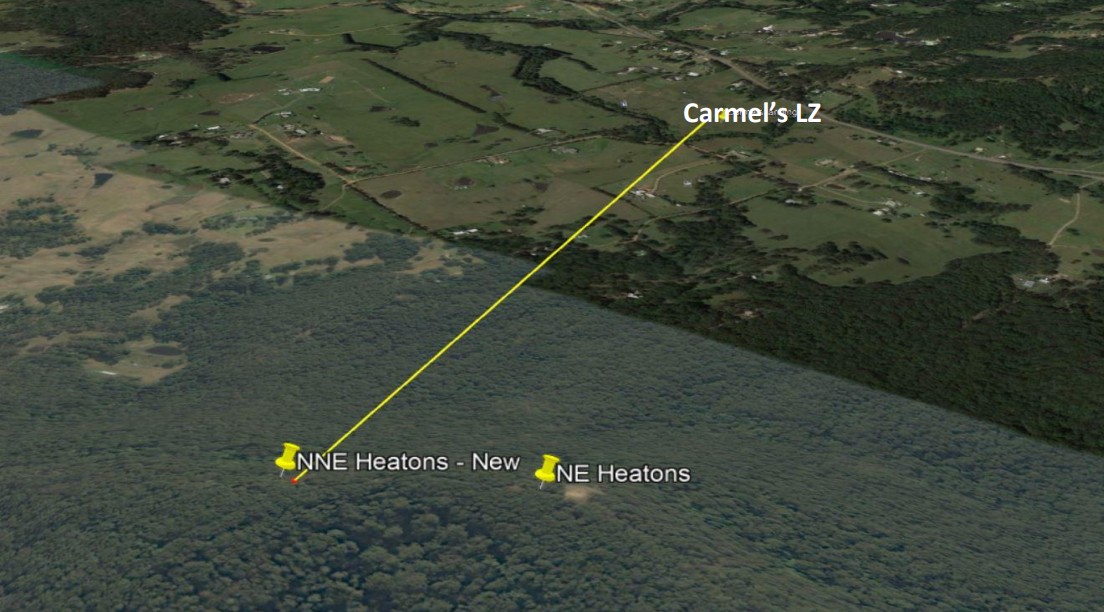
NNE Heaton Lookout
| Type | Hill launch, Inland Site |
| Conditions | NNE at 43° • 4-5 knots ideal |
| Height | 410 metres or 1345 feet |
| Rating | PG 5 rating (This will change as new landing areas are organised) • If local instructor is on launch and gives permission PG4 can launch under supervision. • HG Intermediate |


- Access from North via Sandy Creek Road: not suitable for 2wd
- Access from South via Mt Faulk Road: suitable for 2wd
Landowners - ?
Contact/Responsible
NPC Newcastle, NSW, NHGCDescription
- Winter flying here when the coast is not accessible due to NW winds.
- When plenty of rain and grass is green thermals will not be so active so the drier the area around the better thermals producing.
- Remember winter months the warmest part of day is between 2-4 pm not 1-3 pm like in summer. Although the sun is shining on this side of wall from early morning until 2pm in winter.
- Great phone reception on launch 4 to 5 bars. (Optus/Telstra)
- While on any sites in the Hunter Valley be very mindful of horses and livestock.
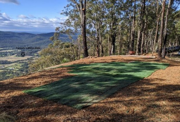
- Please remember to walk the landing area Carmel’s so you can see where you must glide to.
- This site requires a retrieval driver, and the round trip could take between 40-50 mins to landing area (Carmel’s) depending on direction taken.
Airspace
- Class Q – Williamtown airport over launch is Surface to 8500ft.
- If venturing to the west, you will enter Class RMZ – Radio Mandatory Zone – Cessnock airport has surface to unlimited.
- Carmel’s LZ has a 4,500′ airspace height limit.
- Check Aviation maps and heights of flight paths.
- Review all airspace here - AirCheck | Australian Airspace & Flight Display (xcaustralia.org)
Etiquette
- Take food and water and charge flying gear.
- Take only pictures and leave only footprints.
- If heading to this site, it’s always a good idea to take a tree saw or cutters to prune back leaves and bushes so the glider does not snag.
- If going to fly NNE Heaton’s please make your intentions known on the Fly Hunter (WhatsApp) Group.
Weather Stations
- Use Bom readings from Cessnock Airport for what will arrive 20 mins later at NNE Heaton Lookout.
Takeoff
- 410m – 53m = 357m height difference.
- 1880m/357m = 5.3 to 1 Glide Ratio to Carmel’s LZ
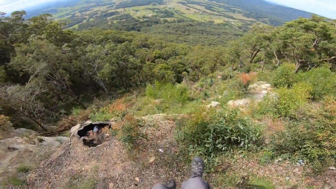
- Great ground handling skills are a must as this launch is very steep to a large drop off into some very large trees.
Landing
- Carmel’s LZ is open to us - Other farms do not approve of us landing on their land
- Coordinates: 32°94’54″S and 151°47’79″E
- Distance from launch: 1.88km
- Elevation: 173 feet or 53 metres
Hazards / Comments
- EN B paraglider and above because of the long glide to landing zone.
- Worst case is light winds 3 knots, insufficient to stay up ridge soaring but enough to make flying to the bomb out difficult.
- If it’s too strong you will be in a head wind and face extreme turbulence due to sheer cliff in front of launch.
- If it’s too light, you must head straight for landing area.
- This site has large trees and a medium glide to landing making a tree landing very possible in bad conditions, ropes, spot-GPS and even some dental floss to enable rope to be raised or lowered if caught in a tree.
Map information
